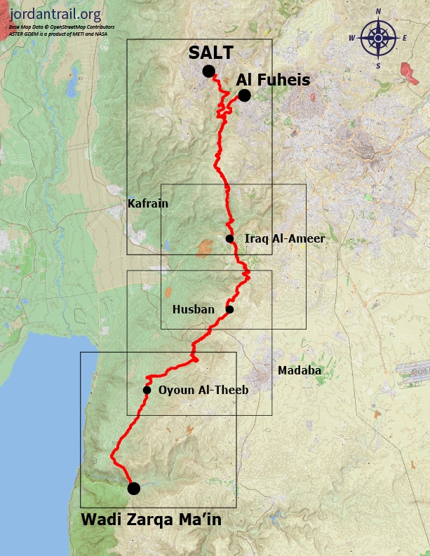
The route starts from the city of Salt, then takes walkers past the ancient palace of Iraq Al-Ameer before descending on the spectacular King Hussein’s Rally Road to the Jordan Valley. The climate and scenery now changes, becoming warmer and more arid as the trail crosses the harsh plateau overlooking the Dead Sea and passes scattered Bedouin camps. Here, the path joins a Roman road connecting the northern Dead Sea with the fortress of Mukawir (Machaerus). Along the way, it passes over a ridge before descending through the basalt cliffs and permanent stream of Wadi Zarqa Main. Walkers then pass north of Mukawir before descending into the deep chasm of Wadi Wala.
Main sites in the region:
- City of Salt
- Fuhais & Carakale microbrewery
- Iraq Al-Ameer
- Iraq Al-Ameer Women’s Cooperative
- Roman Road
- The Dead Sea canyons of Wadi Zarqa Main and Wadi Wala
Salt to Iraq Al-Amir
Head to the Salt city centre and then down the valley following tracks and country roads through small farm holdings and rising up over the hills and down to the Hellenistic site of Iraq Al-Amir with its adjacent caves dating from the Copper Age 5000 years ago. There is a Women’s Craft Cooperative here and homestays.
Distance: 22.2 km
Time: 7 hours
Physical Challenge: Difficult
Trail Challenge: Difficult
Waymarked: No
Fuheis to Iraq Al-Amir
Head to the Fuheis Brewery and then down the valley following tracks and country roads through small farm holdings and rising up over the hills and down to the Hellenistic site of Iraq Al-Amir with its adjacent caves dating from the Copper Age 5000 years ago. There is a Women’s Craft Cooperative here and homestays.
Distance: 15.2 km
Time: 5 hours
Physical Challenge: Difficult
Trail Challenge: Difficult
Waymarked: No

Iraq Al-Amir to Husban
Head south over the hills with good views across the Jordan Valley to Palestine then cross the main road, passing tombs to reach the Husban area.
Distance: 19.5 km
Time: 5 - 6 hours
Physical Challenge: Easy
Trail Challenge: Easy
Waymarked: No
Husban to Oyoun Al-theeb
Head SW and cross Mt. Nebo road before heading generally SW along the elevated Dead Sea plateau. It is a unique area with its own barren beauty with nice views to the Dead Sea and the hills in Palestine.
Distance: 19.8 km
Time: 7 hours
Physical Challenge: Difficult
Trail Challenge: Moderate
Waymarked: No
Oyoun Al-Theeb to Wadi Zarqa Ma’in
Easy walking in wild, barren surrounds as you continue S, still close to higher hills to your E, meeting remnants of the old Roman road from Jerusalem to Mukawir, and following a track left of a camel racing track before crossing the upper reaches of Wadi Himara. On the S side, a track rises up E to meet a road on the skyline, after which the Roman road is found again winding down a surprisingly easy and spectacular descent to above the basalt columned cliffs of the Zerqa Main canyon, which is easily crossed by a path which descends through the cliffs to reach it. The area is dotted with Bedouin camps and you are likely to come across biblical scenes of shepherds grazing their flocks of sheep and goats.
Distance: 21.1 km
Time: 7 hours
Physical Challenge: Difficult
Trail Challenge: Difficult
Waymarked: No
Source:
jordantrail.org