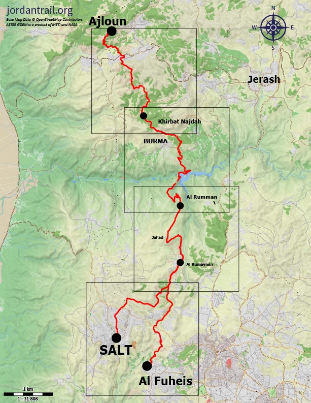
From the village of Burma, the trail descends to the King Talal Dam and provides a view across the large expanse of water stretching eastward between forested shores. It then crosses the dam wall and ascends to a hilltop ridge, which it follows south past rich farmlands to the mixed Christian and Muslim village of Rmemeen with its café and neighboring church spire and minaret. Beyond, it follows a track up a narrow, winding agricultural valley, climbing near Ahliyya University to reach the city of Salt.
Main sites in the region:
- Burma village
- King Talal Dam
- Rmeimeen village
- Town of Fuheis & Carakale microbrewery
- City of Salt
Ajloun Castle to Khirbet Al-Souq
Good views and an enjoyable walk south down the sparsely pine forested hill to Wadi Al-Tawaheen. Once over the wadi, small tracks head back up passing olive groves and avoiding the towns of Anjara and Kufrinja before winding round the W end of the hills above. Country lanes then continue past the old abandoned village of Sarabees with its spring then on over more rolling hills still on quiet country lanes and down into pretty Wadi Mahmoud with its eponymous cliff. A nice path follows the cliff top round to the next valley and Khirbet al-Souq.
Distance: 16.2 km
Time: 5 to 6 hours
Physical Challenge: Moderate
Trail Difficulty: Moderate
Waymarked: No
Khirbet Al-Souq to King Talal Dam
The track heads through a secluded wooded valley onto the crest of the hill with dramatic views over the hillside village of Burma to the King Talal Dam and beyond. Paths then lead down to the east of Burma through old forests and farming areas to the King Talal reservoir and dam.
Distance: 16.2 km
Time: 5 to 6 hours
Physical Challenge: Moderate
Trail Difficulty: Moderate
Waymarked: No

King Talal Dam to Rmemeen
The track heads through a secluded wooded valley onto the crest of the hill with dramatic views over the hillside village of Burma to the King Talal Dam and beyond. Paths then lead down to the east of Burma through old forests and farming areas to the King Talal reservoir and dam.
Distance: 16.2 km
Time: 5 to 6 hours
Physical Challenge: Moderate
Trail Difficulty: Moderate
Waymarked: No
Rmemeen to Salt
Leave the village by the road and continue along a good track up a deep valley between gardens, eventually rising up to cross a highway near Al Ahliyya university, then making your way to the city that is full of history, Al Salt.
Distance: 14.6 km
Time: 6 hours
Physical Challenge: Difficult
Trail Difficulty: Difficult
Waymarked: Ye
Source:
www.jordantrail.org